Tiätuvuárkká:IranOMC.png
Munekejâdem stuárudâh: 708 × 600 kovečuággá. Eres resoluutioh: 283 × 240 kovečuággá | 567 × 480 kovečuággá | 930 × 788 kovečuággá.
Algâalgâlâš tiätuvuárkká (930 × 788 kovečuággá, 53 KiB, MIME-tijppâ: image/png)
Čuákánkiäsu
| Kuvvim |
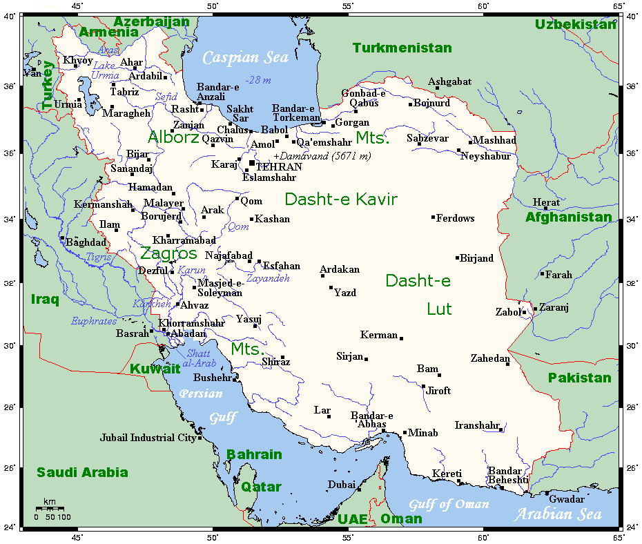
English: A map showing Iran's cities and main towns. This map's source is here, with the uploader's modifications, and the GMT homepage says that the tools are released under the GNU General Public License. |
| Peivim | 6. porgemáánuta 2007 (alkuperäinen tallennuspäivä) |
| Käldee | Siirretty projektista en.wikipedia Commonsiin. |
| Rähtee | Kelisi projektissa Wikipedia kielellä eŋgâlâskielâ |
Liiseens
Kelisi from en.wikipedia.org, tämän teoksen tekijänoikeuksien haltija, julkaisee täten tämän teoksen seuraavalla lisenssillä:
| Taat tiätuvuárkká lii lisensistum Creative Commons Noomâ-JyeviSiämmáánáál 3.0 Ij heiviittum -lisenssáin. Teokseen sovelletaan englanninkielisen Wikipedian vastuuvapauslauseketta. | ||
| Noomât: Kelisi from en.wikipedia.org | ||
| ||
| Lisensointimerkintä lisätiin tähän tiedostoon osana GFDL-lisensointipäivitystä. |

|
Puávtáh kopijistiđ, levâttiđ já/teikâ mutteđ taan äššikirje GNU Free Documentation License -liiseens versio 1.2 tai majemui iävtui vyelni, moh láá almostittum Free Software Foundation peeleest; ij kuoskâ muttuuhánnáá soojijd, ij ovdâlohe teevstâid ige kirjelohe teevstâid. Kopio taan lisensist lii finniimist saajeest GNU Free Documentation License. Teokseen sovelletaan englanninkielisen Wikipedian vastuuvapauslauseketta. |
Alkuperäinen tallennusloki
Alkuperäinen kuvaussivu oli täällä. Käyttäjätunnukset alla viittaavat kohteeseen en.wikipedia.
- 2007-08-06 16:05 Kelisi 930×788× (54211 bytes) == Summary == A map showing Iran's cities and main towns. This map's source is [http://www.aquarius.ifm-geomar.de/ here], with the uploader's modifications, and the [http://gmt.soest.hawaii.edu/ GMT homepage] says that the tools are released under the GNU
Tiätuvuárhá historjá
Peeivi colkkâlmáin uáináh, maggaar tiätuvuárkká lâi eidu talle.
| Peivimeeri/Tijme | Miniatyyrkove | Ooláádmudoh | Kevttee | Komment | |
|---|---|---|---|---|---|
| táálááš | 27. skammâmáánu 2011 tme 08.59 | | 930 × 788 (53 KiB) | Urdangaray | {{Information |Description={{en|A map showing Iran's cities and main towns. This map's source is [http://www.aquarius.ifm-geomar.de/ here], with the uploader's modifications, and the [http://gmt.soest.hawaii.edu/ GMT homepage] says that the tools are rele |
Tiätuvuárhá kevttim
Čuávuvâš sijđo kiävttá taam tiätuvuárhá:
Tiätuvuárhá kevttim ubâ systeemist
Čuávuvááh eres wikih kevttih taam tiätuvuárhá.
- Kiävttu saajeest ast.wikipedia.org
- Kiävttu saajeest en.wikipedia.org
- Kiävttu saajeest es.wikipedia.org
- Kiävttu saajeest eu.wikipedia.org
- Kiävttu saajeest fa.wikipedia.org
- Kiävttu saajeest fr.wikipedia.org
- Kiävttu saajeest hi.wikipedia.org
- Kiävttu saajeest id.wikipedia.org
- Kiävttu saajeest mg.wikipedia.org
- Kiävttu saajeest ms.wikipedia.org
- Kiävttu saajeest my.wikipedia.org
- Kiävttu saajeest nn.wikipedia.org
- Kiävttu saajeest se.wikipedia.org
- Kiävttu saajeest sl.wikipedia.org
- Kiävttu saajeest tg.wikipedia.org
- Kiävttu saajeest uk.wikipedia.org
- Kiävttu saajeest zh.wikipedia.org